A plod across Minch Moor
A few years back my wife bought me a present from the excellent Lou Lou’s Vintage Emporium shop here in Innerleithen. It was a navy scarf with an interesting crest on it. Clearly it was something to do with some group or organisation called The Plodders, but what was it all about?
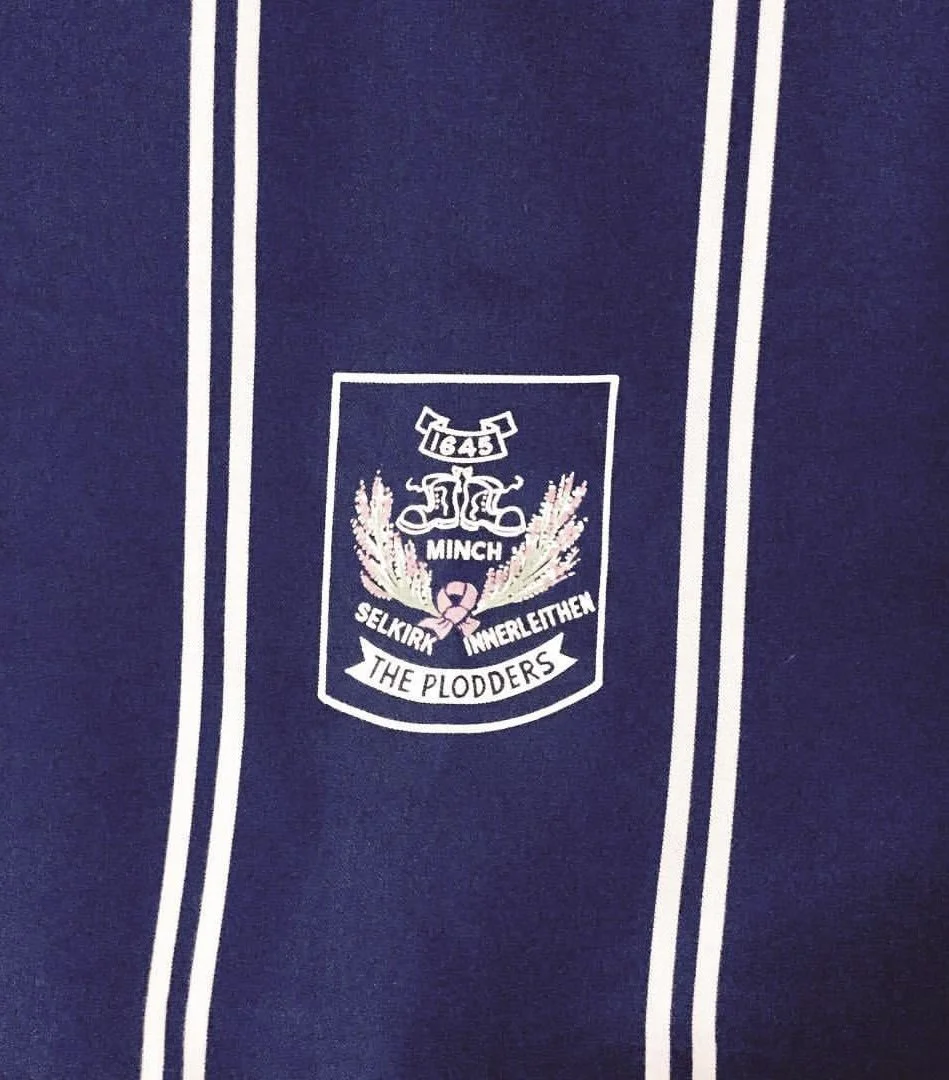
Minch Plodders scarf
It seems that back in the 1970’s (and perhaps earlier) a walking group existed called The Plodders. To join you had to walk the Minch Moor road (or Minchmuir, both versions seem acceptable!) from Innerleithen/Traquair to Selkirk. Male Plodders were given a tie and ladies one of these scarves. A book was maintained in the Philipburn Hotel in Selkirk for any Plodders to log their journey. It has before this been maintained in the now closed Tweedside Hotel in Innerleithen. What a curious and quirky wee club linking two great Border hill towns of Selkirk and Innerleithen. I have very little else about the group and what happened to the book (apparently over 1,000 signatures at one time). If anyone reading this does know more please let me know. Everything I have been able to find out has been from an article by Tom Weir, legend of the Scottish hills, written when he was top table guest of the Plodders in the late 1970’s. Not much else online but given we are only talking 40 years ago there must be stories out there – would love to hear them.
The crest has the date 1645 – this is the year of the battle of Philiphaugh where Montrose used the Minch Moor road to escape after his defeat by the Covenanters. There is a pair of walking boots and a couple of sprigs of heather – familiar plant to anyone who has walked across The Minch. Selkirk and Innerleithen are both named as the terminus points for the ancient road.
I have, as is often the case, gotten ahead of myself. What is the Minchmuir Road? A very old track which for many hundreds of years was a main route from Yarrow to Tweeddale, in the days when the hill tops, not the valley floors, were the preferred transport route. It was used by cattle drovers heading to market, covenanters, armies, shepherds, Kings and Queens - you name it. These days, modern roads roar along the valleys and old routes like this are quiet and used almost exclusively for recreation. The road today contains sections of mountain bike trails and two long distance walking paths (The Southern Upland Way and Cross Borders Drove Road). Most people walking the Minchmuir today will start at Traquair Village Hall where a stiff climb up farm tracks awaits. Arriving at Dean Plantation a path forks to the left – a new, hugely popular route created in 2019 by Traquair Estate which loops around Taniel Hill back to the Red Bull MTB car park. The Minchmuir road presses on, into Forestry & Land Scotland’s Traquair Forest, passing a memorial to dead horses (another wee mystery) and the site of the former bothy. This old shack was removed a few years back, unceremoniously hauled up to the nearby forest road and taken away. The bothy was regularly abused, it was far too close to habitation and not needed by those passing this spot on the Southern Upland Way – comfy beds and campsite are too close at hand. The road then passes over two forest roads and the Clattering Path, another ancient track on this hill, in danger of becoming lost among the conifers at points. Passing ‘Point of Resolution’, a huge artwork of oval shapes cut into the heather, it soon arrives at Cheese Well. It’s said that fairies live at this small spring and you are invited to leave an offering to ensure safe passage across the moor – in the past cheese but more likely now a handful of coppers. Perhaps the Fairies need to get themselves a QR code in this increasingly cashless world.
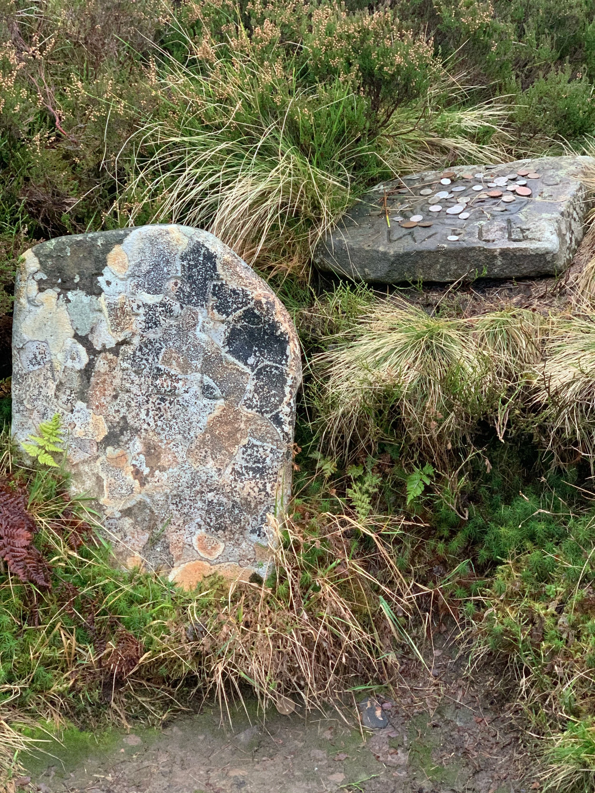
The Cheese Well
A detour takes you to the summit of Minch Moor itself (567m). A fine viewpoint over the Borderlands, worth the extra effort. After taking in the viewpoint and no doubt chatting to some puffed out mountain bikers you head back on to the Minchmuir road, passing through forestry and across tracks branching off to Glenbenna and lonely Lewenshope. A junction is reached just before heading up Brown Knowe. Taking the right hand fork, you have now left the summits of Tweeddale and are dropping towards Yarrow. The Southern Upland Way departs left here, clinging to the high ground on its way towards The Three Brethren and Gala. After a few hundred metres a weathered old stone alerts you to Wallace’s Trench, a linear earthwork of some sort of defensive purpose. A bit like St Mary’s Kirkyard I wrote about the other week, it’s link to William Wallace is dubious but we have already met the fairies on this saunter so whose to argue?? “Hail the legend, tell the story” is how the Innerleithen song goes and it’s pretty apt for these parts.
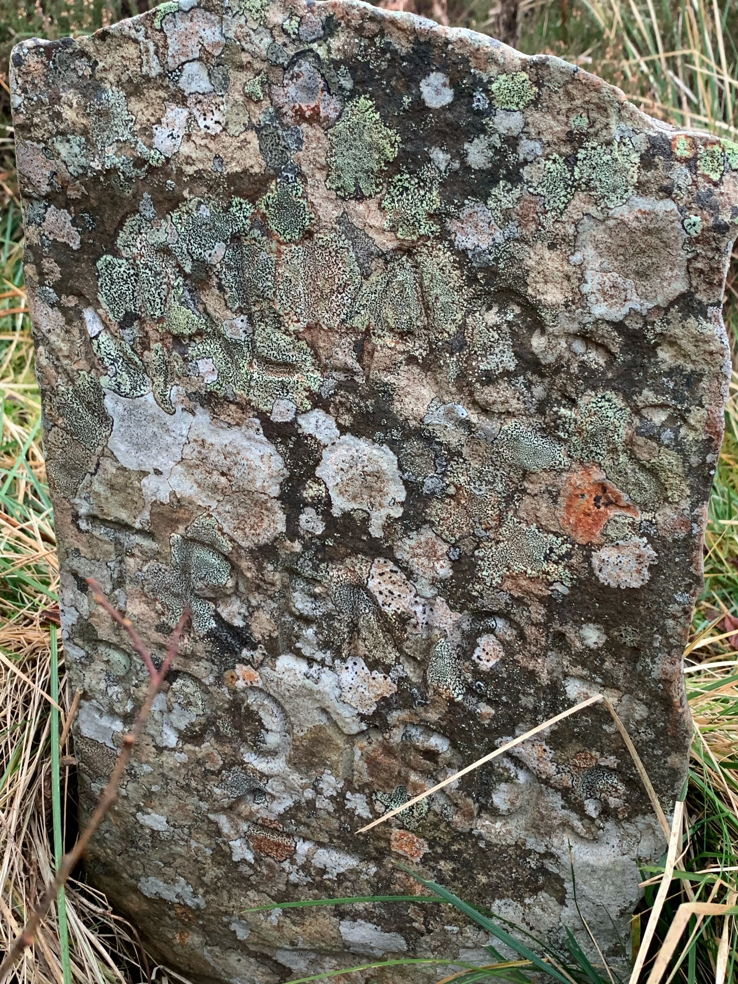
Wallace’s Trench - the stone alerts you to the curious linear earthwork.
The walking here is glorious, a fine descent through lovely country before arriving at farmland and a small shelter belt takes you to the valley floor at Yarrowford, home of the former Broadmeadows Youth Hostel. The Hostel is much missed - you sense that with the newly refreshed outdoor culture around these parts it could be a popular spot. You have now walked the Minchmuir Road and, I suspect, passed a very enjoyable 3 hours or so on the Border hills. Sadly, you’ll not get a pint, coffee or cake at Yarrowford so we need to press on a bit. Cross the Yarrow Water (by bridge, the ford long since replaced) and you enter Bowhill Estate, Borders home of the Duke of Buccleuch, the largest private landowner in the UK. Land Ownership gets some people really rattled, it’s not high on my list of annoyances as I don’t really think about it when out in Scotland – I just follow the outdoor access code and don’t really care if it’s a Laird or Paupers land, they all get the same respect from me. It has been pleasing however to see Buccleuch selling off land, the Langholm Moor project in particular is exciting and inspiring to all south of Scotland communities. Nice and easy walking through the estate brings you to Newark Castle, former residence of the Scott’s of Buccleuch, now a locked up ruin and, the last time I was there, the home of Peregrine Falcons.
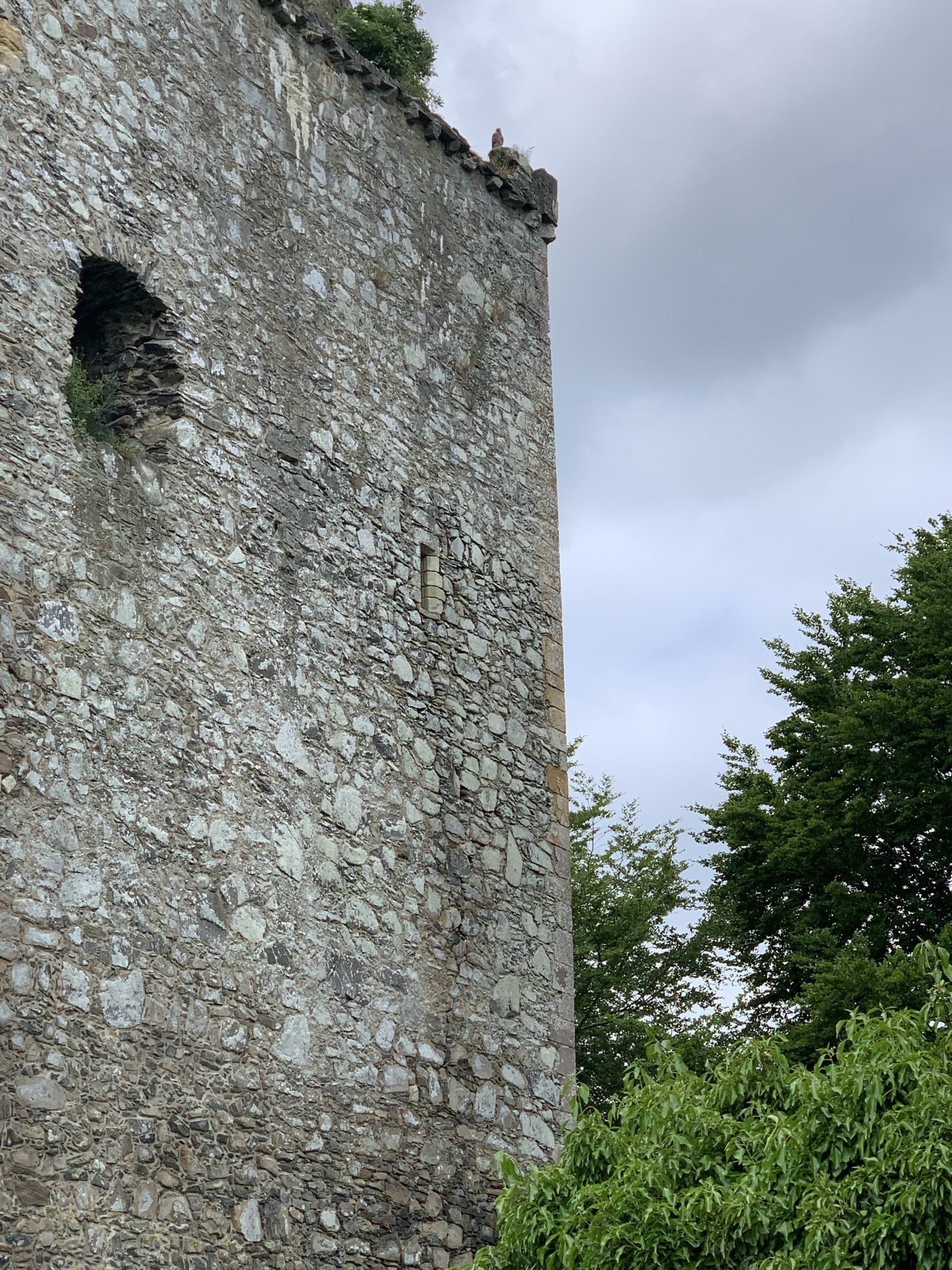
The ruin of Newark Castle, spot the Falcon!
The path winds past the Yarrow Water (some great swimming spots down here) before going near Bowhill House where that coffee and cake can be obtained, as well as a shot on the pretty epic playground (small charge - totally worth it for the flying fox!) If you are determined to get a pint however then we need to keep going. Out of Bowhill (crossing the Yarrow again) and over the road, now on to Philiphaugh Estate. There is an estate road that will take you past the big hoose and eventually out on to the main road, near the Waterwheel Café and the site of the 1645 battle Montrose fled from. By this time the Yarrow Water is no more, it has been swallowed up by the larger Ettrick. Their waters combined, they rush towards The Tweed occasionally at a speed and volume that has necessitated many millions of pounds investment to protect Selkirk from flood. From here it’s past the battlefield and rugby ground before arriving into Selkirk where you can get a 3 Hills coffee or a pint, as a newly minted (unofficial) Minch Moor Plodder.